TROPICAL CYCLONE MONICA
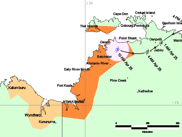
Tropical cyclone Monica's track and threat map (1100 ACST, Tuesday).
It appeared overnight that Monica would travel inland well to the south of Darwin. That has now changed:
At 10 am CST [8:30 am WST] TROPICAL CYCLONE Monica CATEGORY 1 was located over land about 60 kilometres east southeast of DARWIN and 65 kilometres northeast of BATCHELOR, and is moving west at 25 kilometres per hour. The cyclone is expected to continue moving west into the Timor Sea later this afternoon or evening. Monica is expected to re-intensify over water overnight and move southwest towards the north Kimberley coast during Wednesday.Thankfully maximum wind speeds are well down from the 350 kilometres per hour Monica packed when a category 5 storm.
GALES with gusts to 90 kilometres per hour are currently being experienced
within 50 kilometres of the centre. There is a possibility of GALES occurring
over the northwestern DARWIN-DALY district and the southern TIWI ISLANDS this afternoon or evening. GALES may extend southwards along the coast to the NT/WA BORDER overnight or on Wednesday morning if the cyclone takes a more southerly track.
Update: Monica has been downgraded to a tropical low. She is expected to intensify over the Timor Sea and move southwest toward the Kimberley coast:
At 1 pm CST [11:30 am WST] a TROPICAL LOW [EX-TROPICAL CYCLONE Monica] was located over land about 13 kilometres north northeast of DARWIN and 115 kilometres east southeast of CAPE FOURCROY, and is moving west northwest at 18 kilometres per hour. The low is expected to continue moving west into the Timor Sea for the remainder of the afternoon and evening. The low is expected to re-intensify over water overnight and move southwest towards the north Kimberley coast during Wednesday.The Darwin radar is here if you want to have a look.
posted by Anonymous at 10:48 AM |
![]()

0 Comments:
Post a Comment
<< Home